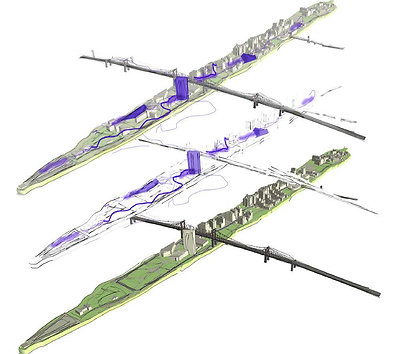


Roosevelt Island Digital Twin
Research project, The Future Automation Research Lab, Cornell Tech, 2019
The Roosevelt Island Digital Twin is a smart planning tool which combines a 3D model of the physical characteristic of the island (buildings, roads, parks), with socio-economic data and demographic information. It is a virtual representation of the island with layers of data and analysis that can be added to physical visualizations. Unlike the use of digital twins in industry, which primarily focus on the built-environment, our emphasis is on the less visible, social aspects of urban life such as inequality and community resiliency.
THE URBAN DISPLACEMENT SIMULATOR is a data-driven tool for predicting the social effects of privatization of affordable public housing. Thorough a microsimulations we predict the demographics changes of Roosevelt Island. The simulation forecasts the socio-economic profile of the households that will be able to stay in their homes after privatization, the profile of those who will be forced to leave, and the profile of the newcomers, providing a new perspective on the invisible impacts of policy choices.
THE UNDERWATER EXPERIENCE is an immersive experience to increase community awareness of climate issues. The Digital Twin is used to forecast projected sea level rise and extent of inundation on Roosevelt Island in 2050. These projections are then rendered into an immersive virtual-reality tour of Roosevelt Island that depicts different possible impacts of flooding and climate change. The tour will be experienced while people are riding the Roosevelt Island red bus. We will bring community members together in focus groups (in person or online) to discuss resiliency planning on Roosevelt Island; to survey their attitudes and note the points of discussion prior to and after the immersive experience.